GIS
Spatial Analysis
Census & Building Spatial Analysis
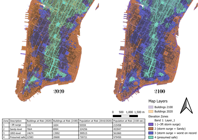
A comparative spatial analysis examining Manhattan’s vulnerability to storm surge under current (2020) conditions and projected 2100 sea level rise scenarios. The project joins census population data with building footprints across four elevation zones — from 3ft storm surge to presumed safe — to quantify buildings and populations at risk.
Key Aspects
- Zone 1 (~3ft surge): 310 buildings at risk in 2020, rising to 1,654 in 2100; population exposure jumps from 55,559 to 215,458.
- Zone 2 (Sandy-level surge): 7,664 buildings at risk in 2020, 8,994 in 2100; affected population grows from 324,256 to 453,947.
- Zone 3 (worst on record): 14,674 buildings currently at risk with 399,515 residents; by 2100, 13,992 buildings and 561,860 people.
- Even in Zone 4 (presumed safe), 22,583 buildings and 730,721 people face potential exposure by 2100 projections.
Tools & Methods
QGIS
GeoJSON
Shapefile
Spatial Joins
Census Data
Statistical Analysis